The University of British Columbia’s Mineral Deposit Research Unit (MDRU) and consulting firm Fathom Geophysics may have identified the regional structural framework partly responsible for silver-gold-copper mineralization in central B.C.’s underexplored Interior Plateau region.
MDRU and Fathom’s work is part of Geoscience BC’s Targeting Resources for Exploration and Knowledge (TREK) project, a four-year program that involved airborne geophysics, geochemistry and geological surveys across a 24,000 sq. km region in B.C.’s underexplored Interior Plateau region.
The Interior Plateau overlies parts of the Stikine terrane — a regionally trending, ancient volcanic island chain prospective for epithermal and porphyry-style deposits, such as Pretium Resources’ (TSX: PVG; NYSE: PVG) Brucejack high-grade gold mine and Imperial Metals’ (TSX: III; US-OTC: IPMLF) Red Chris copper-gold mine in northwestern B.C.’s Golden Triangle district.

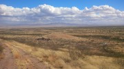
Geoscience BC’s TREK project area in central B.C. overlies a portion of the mineral-rich Stikine terrane, including the Nechako basin, where exploration is hampered by variably thick glacial and volcanic cover. Credit: Geoscience BC.
The partners stitched together regional gravity maps over the project area and applied a proprietary processing technique developed by Fathom. The work highlighted a series of deeply buried, north-trending structures that fall in line with most of the known, Eocene-aged epithermal occurrences in the area. Details of the report can be found here.
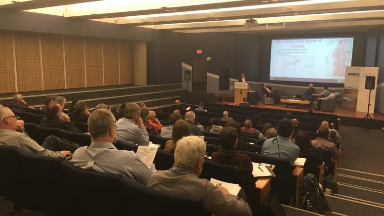
Craig Hart, MDRU’s director and a finalist of Integra Gold’s Gold Rush Challenge in 2016, presented the results during Geoscience BC’s October technical workshop in downtown Vancouver.
“Deep structures tend to focus metal-rich fluids through the crust, so identifying where they are can make for great exploration targets,” Hart told The Northern Miner during an interview on the sidelines of the event. “This study allows explorers to focus on individual features rather than spending a lot of time looking over big areas, hoping they’ll come across something.”
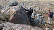
Hart said the TREK project area hosts a number of mineral occurrences “that have the potential to be big,” but exploration work is hampered by the lack of exposure, due to basalt and glacial cover sequences.

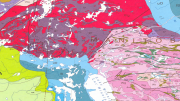
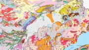
Fathom Geophysics designed a method of grid based, semi-automated structure detection and applied it to the isostatic residual gravity data grid over TREK’s project area. MDRU has correlated several north-trending structures with known mineral occurrences in the region. The white, dotted lines in image outline geological units. Black lines are structures mapped at surface. Showing names are as labelled. Credit: MDRU.
One such project is Kootenay Silver (TSXV: KTN) and Theia Resources’ (TSXV: THH) Two Times Fred gold project, where drilling in 2015 intercepted 1.9 metres of 3.2 grams gold per tonne and 46.48 grams silver per tonne, and 7.6 metres of 1.69 grams gold and 29 grams silver.
The most notable deposit in the region is New Gold’s (TSX: NGD; NYSE-AM: NGD) Blackwater epithermal gold deposit, which contains 344 million proven and probable tonnes of 0.74 gram gold, or 8.2 million oz. gold.
“This is an area that previously had no structural framework or reliable geological map — just little islands of information in a sea of overburden,” Hart said. “Geophysics allows us to see what’s undercover, how the structures are connected and what their relationship is with mineralization.”
MDRU combined existing geological knowledge with the TREK datasets and interpretations from the gravity surveys to refine the region’s geological map, which he says is the foundation of any exploration program. The data is publically available for download from Geoscience BC’s website.
“The magnetic data and the known geology has given us a good idea on what’s happening with the geology near the surface, but these gravity anomalies show what’s happening down in the middle of the crust,” he said. “So if you’re looking for targets, the ones near these deep structures may be the most prospective.”
MDRU performed similar work at its Yukon Gold project, which studied gold mineralization within the Dawson Range and White Gold orogenic belts in the Yukon.
“Western Yukon is another place that has extremely poor bedrock exposure, so we had to start with geophysics to build a structural framework,” he said. “When we did, we quickly realized that a lot of key styles of mineralization were associated with these easterly trending features, and we could identify new ones from the geophysics that we couldn’t recognize from surface.”
Be the first to comment on "MDRU, Fathom Geophysics target central BC"