For more than a few Quebecers, walking amongst some of the earth’s oldest rocks is an everyday occurrence. Almost 90% of the bedrock in the province belongs to the Canadian Shield, a jigsaw of ancient geological terranes with a history dating back 4 billion years.
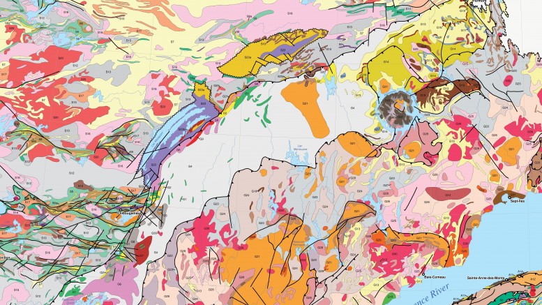
Quebec’s portion of the Canadian Shield consists of the Superior, Nain, Churchill and Grenville terranes. To the east, the landmass is sutured against the Appalachians — an ancient mountain chain that formed during the assembly of Pangaea 480 million years ago — whereas Paleozoic rocks belonging to the St. Lawrence and Hudson Bay platform blanket small parts of southern and western Quebec.

The geological terranes of Quebec. Credit: Quebec’s Ministry of Energy and Natural Resources.
For a detailed geological map of Quebec map please click here
Superior Terrane
The Superior terrane is largely an amalgamation of earth’s earliest volcanic chains dating 4.3 to 2.5 billion years ago, fused by plate tectonics to form what’s known as “greenstone belts.”
Greenstone belts are an ideal host for volcanogenic massive sulphide (VMS) deposits, which formed around underwater hydrothermal vents during early volcanism, and they contain a plethora of orogenic gold deposits.
As the volcanic terranes accreted during mountain building, or “orogeny,” the rocks beneath were baked during metamorphism and released fluids concentrated in gold, which redirected into the many cracks within the crust 2.9 and 2.7 billion years ago.
These orogenic deposits can occur in a number of ways, depending on geological setting: quartz-carbonate veins in structural zones, lenses bounded between different rock types, and/or disseminated to stockworks of mineralization within a sedimentary host.

Tectonic models for typical orogenic gold deposits. Credit: After Groves et. al. 1998.
Abitibi
The most famous greenstone belt in the Superior terrane is known as the “Abitibi.” The belt, which spans the Quebec-Ontario border, has produced up to 170 million oz. gold from mining dating back to 1901.
In Quebec, the Abitibi hosts world-class orogenic and VMS camps, including Val-d’Or, Rouyn-Noranda and Malartic — all of which fall along an east-trending deformation zone called the Larder Lake-Cadillac fault.
The most historic deposits in the Val-d’Or camp are the Sigma-Lamaque orogenic vein-hosted gold deposits, both of which account for 15 million oz. gold of the district’s 20 million oz. historical production.
The Rouyn-Noranda camp got its start in 1920 and is home to over 30 current and former gold and base-metal mines that produced over 19 million oz. gold, 2.4 million tonnes copper and 1.9 million tonnes zinc.
Rouyn-Noranda is famous for its VMS deposits, most particularly Horne, which accounted for 11 million oz. gold and 2.5 billion lb. copper in past production. The deposit is unusual when compared to other VMS deposits in the Abitibi — including Quebec’s Noranda and Ontario’s Kidd Creek deposits — because of its high gold content.
Geologists believe that Horne may have been sweetened with gold by crustal-tapping structures during orogenic gold mineralization in the region.
Another unique occurrence is in the Malartic camp, which is more known for its large-tonnage, low-grade, porphyry gold deposits — an uncommon mineralization style seen in 2.7-billion-year-old rocks.
The camp includes four past-producing gold mines — Canadian Malartic, Barnat, Sladen Malartic and East Malartic — which produced 5.2 million oz. gold between 1935 and 1983. The camp is also home to Canada’s largest gold mine — Agnico Eagle Mines (TSX: AEM; NYSE: AEM) and Yamana Gold’s (TSX: YRI; NYSE: AUY) Canadian Malartic — which hosts 10.8 million oz. gold.
Other well-known base metal and gold camps in the Abitibi, such as Casa Berardi, Chibougamau and Matagami, occur along the Sunday Lake suture zone in the northern extent of the greenstone belt.

Location of major gold deposits relative to regionally-trending structures within Quebec and Ontario’s Abitibi greenstone belt. Credit: Balmoral Resources.
James Bay
Just north of the Abitibi is a variety of greenstone belts within Quebec’s James Bay region. The camp emerged in 2004, after Virginia Gold Mines’ discovery of the 5.4 million oz. gold, sediment-hosted Éléonore deposit, later acquired by Goldcorp (TSX: G; NYSE: GG).
Some of the rocks in Quebec’s greenstone belts were also subjected to swarms of pegmatite intrusive dikes, which formed above slow-cooling, volatile-rich granitic plutons. Pegmatites are known for their unusually large crystal size, and potentially lithium-bearing spodumene crystals.
In the James Bay region, Nemaska Lithium’s (TSXV: NMX; US-OTC: NMKEF) Whabouchi deposit, which hosts in-pit measured and indicated resources of 28 million tonnes of 1.6% lithium oxide, has become a hot spot for lithium explorers in the province.
Churchill Terrane
The Churchill terrane is a geologically complex section of the Canadian Shield, punctuated by many tectonic and magmatic events that occurred between 2.9 and 1.1 billion years ago.
The region is divided into the Ungava Trough, Labrador Trough, Core zone and Torngat Orogen regions, which host a variety of commodities such as copper, nickel, cobalt, platinum group metals (PGM), iron and diamonds.
Ungava
Located on Quebec’s northernmost tip, the Ungava Trough — formerly the Cape Smith Belt — is the epicentre for magmatic nickel-copper and PGM deposits; however, similar styles of mineralization also occur in the Abitibi and the Labrador Trough.
These deposits form when mantle-derived magmas rise and saturate with sulphur while consuming overlying crust. The metal-rich sulphides pool in dormant magmatic chambers that act almost as an eddy for mineralization next to the less prospective and diluted, free-flowing dikes and sills.
Examples are found within Ungava’s Raglan mining camp and the adjacent Nunavik deposit.
Labrador Trough
The Labrador Trough is mostly recognized for its extensive iron formations, toting more than 80 billion tonnes of iron ore resources. The deposits consist of altered and metamorphosed bands of iron and chert, which originally draped over a seafloor some 2.3 billion years ago.
Torngat
The Torngat Mountains are composed of 2.9- to 1.1-billion-year-old gneiss (or metamorphosed granites) and are a favourable environment for potentially diamond-bearing kimberlites. Kimberlitic magmas rapidly ascend through deep fractures in the earth’s crust, assimilating diamond-bearing fragments of rock before venting to surface in vertical, cylindrical pipes.
These pipes aren’t limited to the Torngat region. Over 80 kimberlites in Quebec have been identified across the Superior craton, including at Stornoway Diamond’s (TSX: SWY) Renard mine in the James Bay region, which has measured and indicated resources of 42.6 million tonnes of 0.71 carat per tonne.
Grenville Terrane
As described in the article, “The geology behind Ontario’s world-class metal deposits,” (T.N.M., Sept. 19-25/16), the Grenville terrane is a combination of gneiss and sediments that formed between 2.7 billion and 600 million years ago.
In Quebec, the region hosts a variety of industrial minerals, along with iron, ilmenite and graphite mines. Imerys Graphite & Carbon’s Lac des Îles graphite mine, located in southern Quebec, is the only graphite producer in North America. The region hosts a number of promising graphite deposits, which occur within metamorphosed sedimentary rocks around the edges of intrusives.
Appalachians
The Appalachians has a long and diverse geological history dating between 600 and 300 million years ago, and better described in the article, “The geology underlying the quest for minerals on Canada’s East Coast,” (T.N.M., Aug. 15–19/16).
Near the New Brunswick border, the historical Gaspé copper mine in the Murdochville camp sheds new light on porphyry and skarn-style potential in a terrane more known for its world-class VMS deposits. The mine, which was operated by Noranda from 1959 to 1999, produced 141 million tonnes of 0.9% copper, with some molybdenum credits.
St. Lawrence and Hudson Bay Platforms
From 570 to 410 million years ago, erosion of the landmass flushed sediments over the craton, forming what’s known as the St. Lawrence and Hudson Bay platforms. The units are largely mined for limestone, but two carbonatite-intrusions — Saint-Honoré (in the Grenville terrane) and Oka (in St. Lawrence) — are exploited for its niobium occurrences. Quebec is the world’s second-largest niobium producer.
For more information about Quebec’s mining activities for 2016, please click here, or visit Quebec’s Ministry of Energy and Natural Resources webpage here.

Producing mines in Quebec, 2016. Credit: Quebec’s Ministry of Energy and Natural Resources.


Be the first to comment on "The geology behind Quebec’s world-class metal districts"