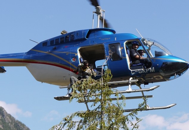
ANAHIM LAKE, B.C. — A typical work day for this Geoscience BC’s biogeochemical survey crew in west-central B.C. gets started with the smell of jet fuel and the high-pitched whir of a helicopter.
The five-person team and pilot are collecting samples from trees spread out over 1,000 sq. km of northern boreal forest northeast of Anahim Lake.
The survey is part of a much larger, 20,000 sq. km project named TREK (an acronym for “Targeting Resources for Exploration and Knowledge”), which is delivering multidisciplinary baseline data to stimulate exploration from south of Vanderhoof to west of Quesnel.
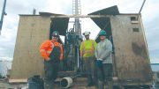
At the base camp, the crew is unpacking gear and busily strapping GoPro video cameras to the helicopter skid, while environmental student Haj Bains fashions a harness around his waist.
Meanwhile, Colin Dunn, pioneer scientist of the avant-garde technique and retired geochemist with the Geological Survey of Canada (GSC), stands alongside as he, quite literally, shows the crew the ropes.
“The helicopter will pull up alongside a tree, and this young man will be sitting outside on the skid, tied on by a rope and harness, of course,” Dunn explains while the team preps for the practice run. “Then he’ll collect a sample bag’s worth of branches off its top.”
Dunn — who’s had his fair share of being tethered to helicopters — was one of the first scientists to investigate biogeochemical markers in tree tissues, and spearheaded its inaugural survey with the GSC in 1988.
He refers to those results — based on a collection of samples over the QR gold deposit, 73 km east of Quesnel, B.C. — as being “proof-of-concept.”
“At the time QR was just a prospect with a couple of drill holes,” he says. “So we wanted to see if there were any values of gold in the trees, and turns out we found anomalously high levels over the deposit.”
The since-depleted mine, currently owned by Barkerville Gold Mines (TSXV: BGM; US-OTC: BGMZF), is a porphyry gold deposit that contains both native and refractory ore within a historical reserve of 2.5 million tonnes at 0.34 gram gold per tonne in the Main zone, 272,000 tonnes at 8.58 grams gold in West zone and 589,000 tonnes at 6.86 grams gold in the Midwest zone.
Dunn says he harbours high hopes for a similar anomalous result over the survey area, considering it’s located 30 km south of New Gold’s (TSX: NGD; NYSE-MKT: NGD) Blackwater deposit. This epithermal gold deposit has proven and probable reserves of 344.4 million tonnes at 0.74 gram gold for 8.17 million oz. gold.
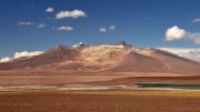
Interpreted to underlie the vast forest is a variably thick volcanic cover sequence called the Chilcotin group. These rocks geographically manifest as a plateau across the region, but Geoscience BC says the older Stikine terrane — a favourable host for large porphyry and epithermal deposits — could crop near the surface.
The Stikine terrane is a northwest-stretching magmatic arc that also hosts Imperial Metals’ (TSX: III; US-OTC: IPMLF) Red Chris and Seabridge Gold’s (TSX: SEA; NYSE: SA) KSM behemouth gold and copper deposits in northwest B.C.
Wayne Jackaman, primary consultant for Geoscience BC — a non-profit organization funded by the B.C. government — says that on top of the 2,300 historical stream-sediment samples for the area, Geoscience BC will take another 4,000 basal till samples across the TREK project — not to mention airborne geophysical lines that total two and a half times the circumference of the earth.
“This is a huge amount of information,” Jackaman says. “There aren’t many projects of this size that have ever been done. It’s pretty unique in the world. The resulting database will probably be as good as you can get.”
He points out that Geoscience BC will make the data public in “the most raw form as possible,” so B.C. explorers will have to piece together and interpret the datasets on their own.
“These are regional surveys — they’re not meant to actually discover, they’re meant to stimulate discovery. So hopefully there’s enough information to pick out some sort of regional trend,” he says, recommending “ioGAS” as a standout software program suited for the task.
Adding to Jackaman’s comment, Dunn explains that the biggest problem with biogeochemical datasets is that plants need certain elements for their metabolism, and thus will concentrate these elements and yield misleadingly high values for them.
Zinc is one such element to be wary of in plants, but Dunn says that cadmium is a perfect pathfinder and better indicates a buried zinc deposit, rather than zinc itself.
Dunn also recalls the last treetop survey — completed in 2005, as part of a federal government initiative called “TGI-3” — identified a strong thallium anomaly, 52 km south of the town of Lumby in southeastern B.C.
“It was years after we published the data, and still nobody picked up on the anomaly and staked the ground,” he says. “I’ve seen the same anomaly over other base-metal deposits in Canada, and I knew it was a pathfinder for lead and zinc.”
So after he retired from the GSC, he finally put his “money where his mouth is,” partnered with privately held RIT Minerals and got his boots out of the helicopter and onto the ground.
“What we found is really proving to be quite a significant zinc prospect, with up to 19% zinc from grab samples at surface,” he says, adding the company is planning a modest exploration program mid-year.
The all-to-familiar burst of the helicopter engine interrupts the conversation, and with the GoPro’s bluetooth linked to their androids and iPhones, it’s clear to see that the bush-savvy samplers are ready for the much-anticipated test-run.
Colin joins the flight crew and offers a few last-minute tips to the student Bains — an avid mountain climber comfortable with ropes and heights — who exudes confidence but admits it’s his first time flying in a helicopter.
With the helicopter now hovering in position beside the tree, those on the ground are blasted by the rotor wash and deafened by the motor as they stand below with cameras pointed up. Bains exits the craft, motions onto the skid and proceeds to rip off small branches.
Backed with a $150,000 budget from Geoscience BC, the team should collect 400 tree samples over four days, with spruce species being preferred.
Dunn says that although the survey appears expensive, the sample value is roughly the same as stream sediments, considering all the factors.
“The biggest advantage with using this exploration tool is speed. You get to cover a lot of ground very quickly in areas that have really poor access,” he says. “Or sometimes you don’t have much of a choice. Either there’s a lack of outcrop or bogs, which can also prevent you from getting an adequate rock or soil sample. So if you can’t use the conventional sample mediums — try the trees.”
“Backed with a $150,000 budget from Geoscience BC, the team should collect 400 tree samples over four days, with spruce species being preferred.”
I’d really like to know if this is meant to imply that 400 samples by helicopter over 4 days cost $150 000, or if that’s the budget for the whole exploration program (including till samples + geophysical).