A first pass of drilling on the 40 Mile project in eastern Alaska turned up several encouraging hits for Full Metal Minerals (FMM-V, FLMTF-O), including a prospective, high-grade massive sulphide discovery.
During the summer drilling campaign, the company intersected 12.1 metres averaging 15.7% zinc, 4% lead and 0.32% copper, plus 110.9 grams silver per tonne (or 3.2 oz. per ton) in the very first hole on the grassroots prospect it’s calling LWM.
Full Metal optioned a 100% interest in the 40 Mile property from Doyon, an Alaskan native corporation, in May 2006 by agreeing to spend US$3.8 million on exploration and by making cash payments totalling US$385,000 over six years, including US$60,000 in scholarship donations. Doyon retains certain royalties on any future production from the property.
Doyon was formed in 1972 after passage of the Alaska Native Claims Settlement Act that set aside more than 320,000 sq. km of federal lands for native groups. As the representative of over three dozen related groups that historically used vast portions of central Alaska, Doyon was awarded the largest land entitlement of more than 50,500 sq. km. Alaskan geological consultants WGM assisted Doyon in its initial land selections.
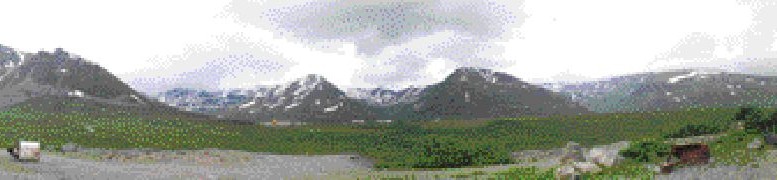
The 40 Mile property encompasses 3,280 sq. km of private lands in eastern Alaska, near the community of Chicken. Road access into the region is provided by a seasonal paved road, called the Taylor Highway, which closes each year in mid-September. The Taylor Highway provides access to the navigable Yukon River, the port of Valdez, the Alaska Railroad and Fairbanks. A network of trails connects the property to the highway.
The project area covers numerous zinc-lead-silver targets and prospective gold and copper showings. In the late 1990s through to 2002, WGM conducted several seasons of exploration on the 40 Mile holdings on behalf of Ventures Resource. Ventures had originally optioned the rights to an extensive 12,140-sq.-km land package, including the Veta and Champion projects, from Doyon in 1996. Today, portions of the Veta and Champion properties form part of 40 Mile.
The Ventures option agreement was terminated in 2005, but not before Ventures pulled some promising holes out of the Lead Creek silver-lead prospect and outlined several new prospective polymetallic targets, including Fish and Little Whiteman (LWM) in the area’s metamorphosed volcanic and sedimentary rocks.
“These two prospects really caught my eye,” says Robert McLeod, Full Metal’s vice-president of exploration. Both Fish and LWM have large vegetation “kill zones” associated with them.
The one at Fish is huge; you can see it from space probably,” McLeod says. “It’s a large accumulation of sulphides. LWM is very distinct as well; it’s almost a square mile right in the middle of the forest.”
Lead Creek
At Lead Creek, 10 km west of the Taylor Highway, a district-scale target (5 km by at least 2.5 km) is defined by a strong multi-element soil anomaly, with rock samples there returning values as high as 5.14% lead, 1.44% zinc, 0.2% copper and 196 grams (5.7 oz.) silver per tonne.
During a 1997 wildcat drilling program, Ventures Resource believed it had nicked the edge of sedimentary-exhalative (sedex) basin, intersecting 1.1 metres of 14.2% lead, 0.3% zinc and 302 grams (8.8 oz.) silver in a turbidite unit. Interestingly, the same hole encountered “manto” replacement-style mineralization overlying the sedex mineralization. Three intercepts of from 2 to 5 metres in hole LC97-7 contained 2.8% to 6.3% lead-zinc and 62 to 96 grams (1.8 to 2.8 oz.) silver.
A second hole encountered a thickening wedge of sedex-style mineralization in a 60-metre westerly stepout. Hole 97-9 intercepted a 14-metre-thick zone that held 5.5 metres of 2.1% lead, 1.5% zinc and 89 grams (2.6 oz.) silver and 2.7 metres of 2.4% lead, 2.7% zinc and 62 grams (1.8 oz.) silver.
Follow-up drilling in 2000 encountered 9.6 metres of 6.4% lead, 0.5% zinc and 799 grams (23.3 oz.) silver in hole LC00-14, a 425-metre stepout from LC-7. The mineralization is contained in a segment of silicified and brecciated limestone, with local skarn and siltstone, which is interpreted to overlie the deeper turbidite unit.
Another eight holes were drilled into the Lead Creek prospect in 2001, but with mixed results. The best hole, LC01-15, intersected 15.4 metres of 5.1% lead, 0.2% zinc and 377 grams (11 oz.) silver, collared 130 metres southeast of hole 14. However, intervening holes were less mineralized and other widely spaced holes contained little mineralization.
“Lead Creek is a bit of a strange one,” McLeod says. “It’s kind of shallow marine breccias and there is syngenetic-looking mineralization and epigenetic stuff.”
The LWM and Fish prospects are 6 km apart and 40 km west of the Taylor Highway. Trails used by local placer miners and hunters extend to within a couple of kilometres of both prospects. The terrain is moderate, rolling covered forest. The area was hit by a massive forest fire in the late 1990s that burnt thousands of square kilometres.
A silver-lead-zinc soil anomaly measuring 1,800 by 365 metres, with zinc and lead values well into the thousands of parts per million (ppm), was outlined by grid sampling. Some 113 samples were taken on 120-metre centres. The only rock found is rare, weathered gossan in soil pits from the heart of the target area. Seven grab samples returned values ranging from 0.3% to 15.9% zinc, 0.18% to 34.4% lead, 0.06% to 2.39% copper and 3 to 471 grams silver. The host rocks are weakly-to-moderately metamorphosed, deep-marine sediments.
“LWM is completely blind,” McLeod says. “There are just a few cobble-size pieces of strongly weathered massive sulphides.”
Full Metal tested the LWM prospect with an initial three drill holes after completing a quick, ground-based gravity geophysical survey.
“We came up with a nice 0.5 milligal anomaly,” McLeod says.
The first hole was drilled vertically and, as mentioned previously, intersected a gently dipping horizon of massive sulphides with impressive mineralization over 12.1 metres, starting 30 metres below surface. The bottom half of the mineralized section was even richer in grade, running 27% zinc, 7.21% lead, 0.56% copper and 201 grams silver (5.8 oz.) across 6.6 metres, including a 3.3-metre interval of 43.7% zinc. The top half of the zone was partially oxidized.
“We are obviously very pleased,” McLeod says.
The 12.1-metre-long intercept is described as coarse-grained, banded massive pyrite, chalcopyrite, sphalerite and galena hosted in brecciated and locally silicified argillite. The hole also encountered dykes or flows of altered felsic rocks.
Collared at minus 67 from the same setup, hole LWM06-2 was designed to test the horizon updip. It intersected 12.5 metres of lower-grade mineralization averaging 2.79% zinc, 2.94% lead, 0.05% copper and 37 grams silver, of which the bottom 2.4 metres assayed 2.98% zinc, 15.2% lead, 0.23% copper and 190 grams silver (5.5 oz.). The intercept was almost completely oxidized, McLeod notes.
Full Metal stepped out a couple hundred of metres with the third hole and hit 8 metres of 3.22% zinc beginning 44 metres down-hole. The company believes the hole was collared in the footwall of the sulphide horizon.
“We just have to go further up the hill next year,” McLeod says.
The 40 Mile project area was never subject to glaciation and, as a result, has experienced deep weathering and leaching.
Fish prospect
In addition to its program at LWM, Full Metal has completed seven drill holes at the Fish prospect, where Ventures had previously uncovered gossanous float scattered along the crest of a ridge. Geochemical soil sampling defined a wide open polymetallic anomaly that extends uninterrupted for 1,500 metres across the ridge. The target is anomalous in zinc, lead, copper, bismuth, arsenic, antimony, cadmium and manganese. Grab samples from the gossanous rubble yielded values ranging from trace to 28% zinc, 0.9%
lead and 216 grams (6.3 oz.) silver in 71 samples.
The widely spaced drilling by Full Metal tested roughly 500 metres of strike length and 175 metres downdip. Four of the holes pulled near-surface oxidized intercepts, including: 11 metres of 4.2% zinc, 0.2% lead, 0.115 copper and 205 grams (6 oz.) silver in hole F06-1; 12.8 metres of 4% zinc, 0.41% lead, 0.09% copper and 181 grams (5.3 oz.) silver in F06-2; 44.4 metres averaging 3.3% zinc, 0.09% lead, 0.1% copper and 34.1 grams (1 oz.) silver in hole F06-5; and 20.6 metres grading 1.7% zinc and 52 grams (1.5 oz.) silver in hole F06-7.
The deepest hole, F06-6, encountered 28.1 metres of 4.9% zinc and 8.3 grams silver (including a 9-metre section averaging 12.3% zinc and 3.7 grams silver) beginning 174 metres down-hole, before passing into fresh massive pyrite mineralization at 207 metres depth.
“There is a little bit of base metal mineralization in there, with good gold and silver values,” McLeod says.
The final 8 metres of the hole ran 1.01 grams gold and 119 grams silver.
“So we now know where the weathering profile is; now we just have to drill a little bit deeper,” he says.
Full Metal has outlined a $1-million budget in 2007, including an aggressive exploration drilling program on the LWM and Fish discoveries that is expected to get under way in May. At Fish, the company will pursue both a zinc oxide target model, as well as deeper drilling to test for fresh massive sulphides. An extensive regional campaign will also assess some of the other base metal and gold prospects.
“There is a lot of placer gold derived in the 40 Mile district, something like a quarter of a million ounces,” McLeod notes.
In November, Full Metal completed a $5-million financing with Canaccord Adams. The private placement comprised 2.2 million units priced at $2.30 apiece. Each unit consisted of one share and half a warrant. The junior has 34 million shares outstanding, or 39.7 million on a fully diluted basis, and is currently trading at around $2.65.
Lucky Shot
Full Metal has 13 active mineral projects in Alaska, including a key 100% interest of the past-producing Lucky Shot gold mine, 80 km north of Anchorage, in the Willow Creek mining district. About 650,000 oz. gold was historically mined from the district, including 250,000 oz. from Lucky Shot between 1921 and 1942. The three largest producers were the Lucky Shot, Independence and Gold Bullion mines. Historic grades averaged between 17 and 69 grams per tonne. Several thousand feet of underground workings were developed at the various mines.
Full Metal optioned a 100% interest in the 35-sq.-km project in September 2004 by agreeing to spend US$1 million on exploration, which was fulfilled in 2006, and by making yearly claim rental payments of US$25,000 until the property is placed into production. The property is subject to a nets profits interest of 10%.
Situated along the southwest margin of the Talkeetna Mountains, Lucky Shot can be directly accessed from Anchorage via Willow along 170 km of paved and well-maintained roads. Elevations in the project area range from 700 metres in the Willow Creek drainage to 1,600 metres just north of the Independence mine.
Ensearch Exploration, a Houston, Tex.-based oil company, purchased the Independence and Willow Creek mine assets, including Lucky Shot, in 1979. The area hadn’t seen any significant exploration since the closure of the mines. A 100-ton-per-day milling complex was built between 1981 and 1983, primarily to process material from Independence. Only 10,000 tons were processed before Ensearch closed the project due to an overall lack of success.
Ensearch carried out surface and underground drilling on the Lucky Shot veins between 1983 and 1985. A 460-metre-long exploration adit was driven below the Lucky Shot mine, from which 11 underground holes were drilled. An additional seven holes were collared from surface, targeting the Coleman block.
Alasko Gold acquired the Lucky Shot mine after the assets were split up and sold. Alasko intended to develop the Coleman block by restarting the Ensearch mill. An aerial tramway to the Coleman Tunnel (originally driven in 1939 to improve ventilation) was installed in 1988 but Ensearch eventually foreclosed on Alasko and the properties were bought by AHI. Solomon Resources briefly optioned the Lucky Shot property in the early 1990s.
Gold mineralization at Lucky Shot fits the classic mesothermal model. Gold occurs in fissure-type quartz veins hosted in gently dipping shear zones cutting the Willow Creek pluton along the southern margins of the multiphase granitic Talkeetna batholith. The batholith is cut by a variety of pre-, syn- and post-mineralized fault zones, which can exceed 30 metres in width as observed in many of the old mine tunnels. Portions of the veins have been offset by as much as 245 metres.
Individual quartz veins in the Willow Creek district reach widths of up to 7 metres at the Fern mine and economic lenses up to 4.3 metres were historically mined from Lucky Shot. However, thick quartz lenses generally do not persist over any great strike length.
“Veins in productive zones pinch and swell dramatically and frequently pass into zones barren of quartz,” states a 2005 technical report of the project prepared by Full Metal. “The shear zones themselves, however, are persistent and are only disrupted by post-mineral faulting.”
The Lucky Shot vein system is 1.6 km long and has been faulted into three segments; War Baby, Lucky Shot and Coleman. The Lucky Shot vein was discovered in 1919 and was mined over a strike length of 460 metres and to a downdip depth of 230 metres from surface.
The Coleman block, a faulted-off western segment, was not discovered until 1939, near the end of the mine’s life.
An oreshoot 1,200 metres long and 150 metres deep has been mined primarily from War Baby and Lucky Shot.
Only about 90 metres of dip extent has been mined in the Coleman block.
Gold occurs as isolated interstitial fillings and/or replacement of earlier sulphides. Pyrite is the most common of the minor sulphides that are present, followed by lesser arsenopyrite and galena. Solomon Resources commissioned metallurgical test work in 1990 that showed better than 92% gold recovery was possible using simple gravity and flotation processes.
After reviewing the exploration results of previous operators, Full Metal carried out an initial assessment in 2005 by drilling seven holes that tested the western extension of the Coleman vein. The holes were laid out based on high-grade intercepts recorded by Ensearch during their drilling in the early 1980s. All seven of Full Metal’s holes intersected the shear zone.
Visible gold, frequently associated with telluride, was observed in three of the holes. The best results came from hole C05-12, which intersected 4 metres averaging an uncut 219 grams (6.4 oz.) gold, including a 0.7-metre interval of 1,267 grams (37 oz.). In addition, hole C05-9 cut 62 grams (1.8 oz.) across a true width of 2.7 metres, including 179 grams (5.2 oz.) over 0.5 metre. Both intercepts are about 200 metres updip of the historic Colman underground workings.
The Coleman block is open both to the west and downdip. The eastern limit is defined by the Lucky Shot fault, which separates the historic Lucky Shot and Coleman workings.
2006 program
In 2006, Full Metal completed 73 holes in 14,000 metres of drilling aimed mostly in the upper Coleman fault block. The objective of the program is to build indicated and inferred resources. Most of the drilling was done on 25-metre centres, stepping out to 50 metres.
“We hit some real high-grade material but we also found it was little more shootier than we thought, but that’s the nature of these mesothermal systems,” McLeod explains. The variable results suggest that the Coleman block has several discreet plunging shoots.
Some of the better hits included: 4.5 metres of 51.5 grams gold (1.5 oz.) in hole C06-16; 1.2 metres of 134 grams gold (3.9 oz.) in h
ole C06-19; 2.5 metres of 60.3 grams (1.8 oz.) in hole C06-21; 1.7 metres of 34.1 grams (1 oz.) in hole C06-27; 5.2 metres of 7.1 grams gold in hole C06-48; 4.9 metres of 11.6 grams in hole C06-60; 2.9 metres of 23.7 grams in hole C06-80; and 1.7 metres of 82.6 grams gold (2.4 oz.) in hole C06-81.
Drilling tested about 260 metres of strike length. The closest holes to the old underground workings were about 100 metres updip. A National Instrument 43-101-compliant resource estimate is expected sometime in April 2007. Full Metal has already committed to a 10,000-metre drilling campaign at Lucky Shot starting in the spring.
According to McLeod, the most important result from the 2006 drilling was the “blind” discovery of a northeast extension; a faulted offset of the Lucky Shot shear system underneath the valley floor beyond the past-producing War Baby block. The last hole of the program intersected a narrow 0.4-metre interval grading 19.3 grams some 300 metres below surface and 100 metres downdip of the old War Baby workings in an area Full Metal is calling the Murphy block.
Be the first to comment on "Full Metal makes Alaskan discovery"